Defining the extent of aggregate geology
The first stage of this project was to identify the location and extent of geological deposits that have in the past, or could in the future, produce aggregates. The relevant geological deposits comprised superficial sand and gravel deposits and bedrock outcrops.
This was based on BGS data by permission of the British Geological Survey and has now been completed.
Sands and Gravels
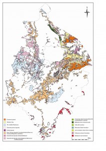
Sand and gravel deposits are found along the main river valleys and covering large areas of the Arden between Solihull and Coventry as well as the area between Coventry, Rugby and Nuneaton.
Along the river valleys they have generally been deposited by past river action. In the central area between Solihull and Rugby, they are more usually glacial in origin.
Crushed Rock
Bedrock areas are more restricted and consist of ironstone outcrops along the edge of the Cotswolds in the south of the county and igneous intrusions in the Nuneaton area in the north.
British Geological Survey © NERC.
All rights reserved. IPR/79-15W